Showing posts with label rivers. Show all posts

Sunday, February 1, 2015

Funding uncertainty for the Plan Loire 2015-2020


For 20 years a series of multi-year plans have guided management of the Loire River basin.  Generally, each "Plan Loire Grandeur Nature" has concentrated on flood control, restoration of natural habitats, and tourism.  (Persuading UNESCO to designate the central Loire with all of its chateaux as a “World Heritage Site” was a project in one of the early plans.)

The fourth plan, due to run from 2015 through 2020, has been adopted, but France’s recent territorial reforms could end up undermining part of its funding.  Europe committed 33 million euros under its program for regional development back in November of last year.

But the domestic commitment is more complicated.  Plan funding comes from the national government, the regions within the Loire basin, and in some cases individual departments.  Funding commitments are currently being negotiated through a process leading to a contract between the regions and the national government ("Contrat de plan interrégional État-Région" (CPIER)).

The problem for the 2015-2020 Plan is that over the next year regional, and in some cases departmental, organizational arrangements are being reshuffled following Paris’ decision to reduce the number of regions from 22 to 13.  For the regions and departments it’s hard to commit to funding a six-year plan when you’re not sure what your own finances will be a year from now.

Wednesday, January 28, 2015

A river-friendly dam? Poutès update

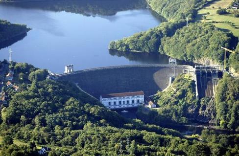
Hydroelectric dams may produce clean energy but they generally mess up a river.  Still, a redesigned dam in the mountains of central France might be a model for accommodating river environments with energy production.

© Richard Mounts
Since 1941, a 56-foot high dam in the upper reaches of the Allier River at a place called Poutès has generated power for Électricité de France (EDF).  For years, environmental groups argued that the dam blocked migrating salmon from reaching spawning groups and disrupted the river valley ecology by interfering with the normal flow of sediments.

EDF’s operating license expired in 2007 and environmentalists opposed renewal.  They wanted to see the dam decommissioned and dismantled, as had been done a few miles upstream at Saint-Étienne-du-Vignan (in the department of the Lozère near Naussac Lake).  On the opposite side, public officials and others pushed to preserve a source of clean energy and, along with it, the tax revenues to local communities.
Existing dam.  ©EDF

The standoff was finally resolved in July 2011 when EDF presented a new version of the dam.  This design would lower the dam to just 13 feet and would include accommodations for fish and sediments.  For the last three years, EDF has been building and testing a 1/13th scale model of the “new Poutès”; they avoid calling it a dam.  Besides redesigned fish ladders, the new installation will include special valves to be opened during high-water periods to allow sediment flow.  A lower barrier will also mean a smaller reservoir and a more natural river valley.  Currently, the water backs up for more than two miles.  When the new structure is completed, this will drop to about 300 yards.  Even with the much lower structure and freer water flow EDF expects to continue to generate 85 percent of the power current output.

Proposed dam.  ©EDF
The project is back in the news (at least in the Haute-Loire) because a public comment period opened at the beginning of this month.  The issue is still the decision by the Ministry of the Environment to grant EDF a new 50-year operating license.  At the beginning of January, residents in the 26 small communities along the affected portion of the river all received a brochure with information about the project and how to submit opinions.  This time, given support among all the previously contending parties, serious opposition seems unlikely.  The comment period closes on February 5 and some expect government approval within a couple of months.  EDF says it would start construction towards the end of 2016, with completion likely in about three years.

Wednesday, March 12, 2014

Italian jobs in the rivers?

A recent article in an Italian on-line environmental publication, Greenreport.it, provides a reminder of a looming deadline for water quality in lakes and rivers.  An E.U. directive from 2000 sets the deadline for Italy and other member countries for next year.  Those failing to meet the standards face economic sanctions meant to be serious enough to draw governmental attention.  So far, though, the new Renzi government hasn’t seemed to give water issues, or the environment generally, much attention.  The Greenreport article, perhaps as a kind of signal flag aimed at Rome, includes a reminder that environmental cleanup can produce a lot of jobs.  It cites a recent Ambente Italia report estimating that an investment of 27 billion in the water sector over the next ten years could produce something like 45,000 jobs.  I have a feeling that, rather than new investment, we're more likely to see Italy asking Brussels to postpone the deadline -- and sanctions -- for a few years.  And they probably won't be alone in making the request.

Il Fiume Topino near Cannara, Italy.  More of an irrigation canal at this point.  © rmounts

Wednesday, February 19, 2014

The Cher "Canalized"


La Nouvelle République recently included a curious article about the Cher River and an organization, “Le Syndicat du Cher canalisé.”

Copyright La Nouvelle République
The article describes the organization’s plans for 2014, which are supposed to include renovation of dams on the Cher, regulation of its flow, and balancing recreational use and environmental preservation.  The article’s tone was entirely matter-of-fact; no issues; nothing about the possibility that the Syndicat’s plans for the dams, for example, might raise any questions.

It made me curious about a river described as canalisé and an organization that aims to preserve that condition by restoring dams and yet also claims to be preserving the environment.

A separate organization, “Les Amis du Cher Canalisé,” offers an interesting history of transporation on the river.  In 1828 the Canal du Berry opened as far as Noyers-sur-Cher providing the first part of a link between Montluçon and Tours.  The second part involved building a series of needle dams and locks to allow barges to connect to the Loire at Tours.  Needle dams, developed in France at the beginning of the 19th century, are a type of low dam made of wooden slats, or needles.  They aren’t intended to be water tight and needles can be added or removed to control the water level behind.  The series of these dams on the Cher was completed in 1841.  “Canalisé,” it turns out, doesn’t mean “channelized,” in the sense of the arrow-straight, cement-lined troughs the U.S. Army Corps of Engineers likes to construct.  It means, rather, that, with the needle dams, the river could be used for transport as if it were a canal.  And it appears it was.  The “Amis” cite records reporting that 4,600 barges passed along the canalized portion in 1846.  By the 1920s, this canal, like most others, had lost out to railroads and roadways.  Eventually, in 1955, the national government removed the canal from its list of navigable waterways and responsibility for the canalized portion was handed over to the two departments through which it flows, the Indre-et-Loire and the Loir-et-Cher.  For several years, the departments pretty much ignored the river.  Then, in the 1990s, they became interested in the recreational and tourist potential.  Through an interdepartmental entity, the Syndicat, they started restoring the needle dams to provide water deep enough for boating and canoeing and, eventually, a floating restaurant.

Meanwhile, in 2002, the national government declared the Cher to be a natural habitat for several migratory species of fish, including lampreys, shad, and eels.  Within five years, dams would need to be modernized to allow for their passage.   More or less since then there have been an on-going tensions between the Syndicat and Amis on one side, and environmental organizations on the other.

Recently, SOS Loire Vivante and several other environmental and fishing organizations have written to local authorities objecting to recent repairs to several of the needle dams damaged in flooding in 2013.  They note that the dams have not been modified to provide for migratory species as the law requires.  They propose what they term a compromise under which some of the dams would be maintained, provided they’re modified to accommodate migratory fish, and others would be dismantled.

Friday, January 24, 2014

Chemicals in the Elk River

It's a little while now since the spill of toxic chemicals into the Elk River in West Virginia.  For several days, after a storage tank owned by the wonderfully-named Freedom Industries leaked 4-methylcyclohexane methanol, or MCHM, into the river, West Virgina drinking water service was virtually shut down.

Last Sunday, the Washington Post published a useful article with a broader look at regulatory oversight of toxic chemicals.  In fact, Joel Achenbach, the reporter for the piece, leaves the impression that there’s little or none.  He reports that when officials were scrambling to deal with the leak and assess its seriousness, they had next to no information about the chemical contaminating the water supplies.  According to his article, the MCHM safety data sheet that officials were probably looking at anxiously, uses the phrase “no data available” 152 times.

That would seem unacceptable when so much emphasis is placed on the safety of the things we eat and drink.  But a spokesperson for Freedom Industries said the company was, in fact, following stricter European Union standards in the data sheet; under U.S. regulations, she said, they didn’t even need to say that much.

So the Elk River spill points out the need for better information about and regulation of industrial chemicals, right?  Right.  But the most prominent proposed legislation, drafted by the late Frank Lautenberg (D-NJ) and David Vitter (R-LA), both from states with sizable petro-chemical industries, would, if anything, weaken oversight.  Elk River may have raised the salience of the issue for a while, and prompted an effort towards stricter regulation.  Here’s hoping something comes of it.

Sunday, January 19, 2014

Flood control on the Loire

Brives-Charensac is a small town on the Loire River adjacent to Le Puy-en-Velay.  It’s deep in the Massif Central, not far from the river's headwaters.  In 1980, waters from a massive rain storm swept down the river, flooded parts of the town and killed nine people.  Ever since then flood control has been a sensitive issue for the Brivois.
© Zoomdici.fr
A push in the late 1980s to build a dam at Serre-de-la-Fare upstream from the town was in large part justified as a way to prevent a repeat of the 1980 flooding.  But several years of environmental opposition to the dam, including a five-year camp-in on the construction site, finally convinced the government that, technically and environmentally, it made more sense to use land use controls than dams and levees to prevent flooding risks.

In the mid-1990s regulations were adopted to prevent new construction in at-risk zones, business installations were relocated with public assistance, and several projects were carried out to improve the river’s flow through the town.  Last week, the issue of flood control and land-use planning was revived when the government presented new maps with new definitions of at-risk areas in the flood plain.  Generally, the new maps double the lands within Brive defined as having a potential for serious flooding.  The maps are still in draft form for purposes of public discussion.


In large measure the new maps area a response to the "Xynthia" storm in 2010 that hit coastal areas, ripping through levees, destroying property, and killing more than 50 people.  Now, new government rules now place much less faith in levee protection.  If the new maps are finally adopted, Brive, and other towns along the river, will need to substantially revising the zoning rules and place new limits on areas of permissible development.  Understandably they are not happy.  The maps area expected to be finalized by the end of this year.

Friday, October 25, 2013

Flooding in Italy

Two years ago today, heavy mountain rains caused flash flooding in Cinque Terre and other parts of Liguria in Italy. Lynda and I visited the area in 2006 and spent a wonderful day walking the narrow trail above the Tyrrhenian Sea from Riomaggiore to Monterosso. Vernazza (below) was about the mid-point of the 10 km walk.  We never thought of anything like this.  The flood waters rushing down the narrow canyons from the mountains to the ocean directly and indirectly 13 killed people and destroyed homes and businesses.  The area is still getting back on its feet.
111115-vernazza-h.grid-6x2-2013-10-25-20-28.jpg
Flash flood waters emptying into the harbor at Vernazza. © Tom Wallace


So, along with news about Berlusconi's latest legal problems and the Letta government's new budget proposals, flooding has been on Italian minds lately, at least some Italian minds.

Gian Vito Graziano, president of the National Geologists Council (il Consiglio nazionale dei geologi) warned recently of the likelihood of more such flooding and likely deaths. Everywhere in Italy, he said, misuse of land -- urbanization of agricultural fields, in-fill of wetlands, dikes along rivers -- has reduced its ability to absorb heavy rains like those that hit Liguria.

Unfortunately, the country’s creaky political institutions and sputtering economy (to say the least in both cases) probably mean that heads will be nodded sincerely, but little will change and the flooding risks will remain. (I recognize one could say the much the same thing about this country’s Republican-sabotaged politics and precarious economy and their effects on environmental policies.)

Friday, September 13, 2013

Colorado flooding

For four years back in the early 1970s, Lynda and I lived in Boulder, Colorado.  It's been a while since we've been back, but i can still sort of recall the little stream that came down out of Boulder Canyon.  So the videos and pictures of the recent flooding are that much more remarkable, if not incredible.  The New York Times reports that 4,000 people in Boulder Canyon were told to evacuate immediately; and another 4,000 were told to move to higher floors.  The main campus of the University of Colorado has been closed.  Early estimates report that 20 percent of the university's buildings have had some amount of water damage, including the theater and main library.  There have been three reported deaths so far and more flood damage in and around canyons all along the Colorado front range.  The state's governor, John Hickenlooper, has referred to it as among the worst flooding in the state's history.

How could that much water collect and roar down the canyon and cause all that damage?  The Times reports 15 inches of rainfall in the past few days.  And where the rain fell on hillsides above Boulder and other canyons that had been burned by recent forest fires, there was nothing to absorb it.  Worse, heat from the fires had created a layer of soil that is virtually waterproof.  The rain falls and virtually all of it immediately heads downhill, collecting dirt, rocks, and all sorts of debris as it goes.  It knocks down and sweeps along almost everything in its path and doesn't stop until it looses energy on the plains beyond the mouths of the canyons.

After people recover as best they can from the shock, and after the cleanup, I hope the papers will continue to cover how, if at all, Boulder and the other communities respond.  It's a version of the situation following almost any weather-related disaster.  It's on-going in New York and New Jersey in the aftermath of Hurricane Sandy.  Is this combination of bare hillsides after forest fires and heavy rains an extraordinary, highly unlikely ever-to-be-repeated event?  Or does climate change make such extreme weather, even without the forest fires, more likely?  Is there a need to take steps to mitigate damage from similar floods in the future?  Would this influence land use decisions in the canyons?

Saturday, June 22, 2013

World Heritage "curse"?


Later this summer I'll be biking through a part of the Loire Valley that's been designated a UNESCO World Heritage Site.  The designation, which only occurred about ten years ago, is meant to help preserve, and at the same time draw attention to, the remarkable chateaux along the middle portion of the river, and to their history.  I suppose it's not unexpected that these two objectives should end up creating tensions.  The people who want to draw in tourists and the people who want to preserve sites aren't necessarily the same.  And once the UNESCO designation has been achieved, they aren't likely to have the same interests.  In fact, they may well end up in conflict.

A recent example of this is the Loreley Plateau, a site along the middle portion of the Rhine River, about 80 km west of Frankfurt, Germany.  (Hat tip to M. McDonald)  The plateau is at the top of a nearly 400 foot-high rock at the narrowest point of the Rhine.  The rocks below and the turbulence in the river have caused numerous accidents over the years and helped give rise to local legends.  In 2002, the rock and the plateau were included in a 65 km stretch of the river receiving UNESCO World Heritage designation.

Google Satellite identifies several hotels, restaurants and a sizable camping ground on the plateau, all of which feature great views above the river and probably benefit from the UNESCO designation.  But it seems that a recently-constructed summer bobsled run was one thing too many. 
http://www.spiegel.de
Just this week, the World Heritage Committee issued a statement declaring that the run was "not compatible with the outstanding universal value of the World Heritage property" and calling for its removal.

I'll be on the lookout for tourism run amok when I'm riding past the Loire chateaux.  But I have to say I have trouble seeing this bobsled run as an example.  The World Heritage Committee seems to be okay with places to eat and sleep and park your camper van.  But the bobsled run seems to strike them as just too touristy, too tackily mass touristy. 

http://www.spiegel.de
 I'd probably prefer a beer on one of the restaurant terraces before I took a run on the bobsled.  But it's a little hard to see, from the photo here, how it has more of an impact on the site than do the other tourist facilities.

Meanwhile, commercial barge traffic continues along this stretch of the river below and a little over two years ago one of them capsized near the Loreley rock spilling 2,400 tons sulphuric acid into the river.  One wonders whether the barges and their cargos are "compatible with the outstanding universal value of the World Heritage property?"

Thursday, June 20, 2013

Messy is better


Could a small boat, a chainsaw, and a hand winch be enough to bring a river back to life?  Possibly, in some cases.  An example comes from the River Bure, a short river, only about 50 long, flowing through Norfolk in northeastern England.  It joins the River Yare at Great Yarmouth just before reaching the North Sea.


A little north of the city of Norwich, the river passes through the Blickling Estate, a large country house and grounds managed by England's National Trust since the 1940s.  In the past, the river had been dredged and meanders blocked off to accommodate several nearby mills using the water power.  Trees that might fall into the river were regularly cleared away.  A visitor to the Estate might see an attractive country steam (below), but, in fact, the channelizing and debris clearing had seriously undermined its vitality.   


© D. Brady.  The National Trust
These measures, it appears, had caused the flow of water to slow down.  As it did so, silt, normally carried farther downstream, fell out and gradually covered over the gravel in the river bed.  Over time this process eliminated many of the spawning grounds for the local brown trout.  Eventually local fishermen and National Trust staff realized something needed to be done to improve the river's ability to support the fish and other plant and animal life.
 

In 2008 and 2010 the two groups undertook to recreate something like natural stream conditions.  This turned out to be fairly easy.  They carefully picked out trees that looked like they were about to fall into the river on their own, cut them, and let them fall into the river, branches, leaves and all.  In a few cases, they needed the hand winch to drag them into the water.

The result has been impressive.  As water squeezed its way around and through the debris, it accelerated and, in doing so, began to wash the silt off of the gravel.  With this, the trout began to return to spawn; the fishermen have recorded their increased numbers.  Some of the silt has been displaced out to the river banks where it has allowed new plants to take root.

© D. Brady.  The National Trust

The result (here) may be a messier looking river, but it appears to be much healthier.  And the lesson has been picked up by environmental agencies in the area; they are now much more likely to let trees that fall into streams just stay there.


Thursday, June 6, 2013

Peaking releases and fish

Hydropower may be a clean, renewable form of energy, but putting a dam across a river certainly has consequences for life in and along a river.  This is particularly true when the power station operates in a "peaking" manner, periodically releasing water from the reservoir to supply extra power.

Recently, France's Fédération Nationale pour la Pêche (National Federation for Fishing) and Électricité de France (EDF) announced the results of a joint six-year study (2006-2011) of the impacts on the down-stream fish populations of these peaking releases (referred to as "éclusées" from the opening of the "écluses" or locks to release the water).  The report covered the first phase on an on-going evaluation and looked at water releases from the dams at La Roche-aux-Moines and Éguzon, both on the Creuse River about 50 km south of Châteauroux (about 150 km southeast of Tours and the Loire River).  Data was collected at some 50 points identified as fish spawning grounds.

Éguzon Dam.  © La Nouvelle République and Patrick Gaïda

Somewhat surprisingly, the study found that the impacts weren't all negative; they varied according to species of fish.  Some seemed to do just fine; others not so fine.  Among the former were barbels, a small carp-like fish, and chub.  Among the latter were perch, trout, and sanders, all of which showed declining numbers.


Already, EDF has agreed to modify its water releases to keep the downstream water levels within specified minimum and maximum amounts.  As reported in the newspaper La Nouvelle République the fishermen and the power company, having collaborated in this project, seemed anxious to find ways to manage the river to satisfy everyone's concerns, or at least those of fishermen and power generators.  I'm curious, though, about what regulatory requirements apply to habitat protection along rivers in cases like this, and the extent to which those are taken into account.  Is there a possibility that governmental agencies may be ceding responsibilities to private interests in this case?

Wednesday, June 5, 2013

The Gerbier is free

Among the world's rivers, France's Loire must have one of the most clearly marked starting points.  This is le Gerbier de Jonc, a volcanic mound in the department of the Ardèche, where several springs emerge from its base, quickly join, and head off for the Atlantic some 600 miles away.
© Richard Mounts


Despite being rather remote, it's estimated that the site draws nearly a half million visitors a year, many of whom pay a euro or so and push through the turnstile to hike to the top for the impressive views.  

© Richard Mounts
© Richard Mounts
Not withstanding its status as a kind of national monument, le Gerbier and the surrounding land is privately-held.  But starting this summer, the admission charges will be dropped and access will be free.  This comes as the result of a 30-year agreement between the land owners and the department of the Ardèche.

I worry about too many people climbing over an already fragile ecology.  But apparently the department plans new protective measures, along with programs to highlight the unique characteristics of the setting.  I may have to go back.

Wednesday, May 22, 2013

Grande Pioggia New York

Well, there was plenty of water involved in last Sunday's Gran Fondo New york, but it wasn't the Hudson.  It was the rain.  It seemed to have come, more or less, out of nowhere.  Last Thursday, when I packed, the weather report said sunny with temperatures in the mid- to high-60s.  And that was still pretty much the prediction on Friday and Saturday after we'd arrived in New York.  But Sunday morning, when I looked out the apartment window at about 5 a.m., the streets were wet.  The weather report now showed a chance of rain, but only 30 percent through the morning, with the probability going up to 50 percent about 2 p.m.  I figured that would be an incentive pushing me to get done.  So I set off, worried more about keeping warm, wearing DC Velo kit -- arm warmers, a vest and a long-sleeved windbreaker -- over the regulation chartreuse GFNY jersey.  On the George Washington Bridge I think we were mostly worried about getting underway.
But, as soon as we left the bridge's protection, we met light, chilly rain.  So much for the 70 percent change of no rain.  It was 100 percent the entire day.   Early on, I sort of wished for some mechanical failure to take me out without my having to think about it.  But that didn't happen and, in fact, I felt pretty good.  Then I thought, okay, I'll make it to Bear Mountain, the half-way point, and knowing after that that I was heading home should keep me going.  

It didn't.  At about mile 70, the Rockland County Boulders baseball stadium, I was wet to the skin and couldn't stop shivering.  I climbed off.  But at least I had lots of company.
 Maybe there was more excitement around the finishing area when the earlier riders had come in.  But by the time the bus delivered us dropouts, it looked pretty sad.  The few people left were huddled under the tents trying to stay dry and moderately warm.  Riders straggled across the finish line.
Eventually, a truck ferrying back and forth to transport bikes down to those of us who'd dropped out, delivered mine.  By then it was 7:30 p.m.  I think we were just about the last group of riders taking the Weehawken Ferry over to Manhattan and a warm shower.  But despite all of that, I'll probably try again
next year.


Friday, May 17, 2013

River rides

I've had a lot of posts here about rivers.  This is another one, but a little different.  Sunday, I'll be riding my bicycle along the west side of the Hudson River from the George Washington Bridge up to Bear Mountain, then back down to Weehawken, New Jersey.  I'll be riding in the 4th annual "Grand Fondo New York."  The route is on the map below.  This is a semi-competitive race/ride modelled on similar events in Italy, France, and several other European countries.  Unfortunately, even though we're following a route whose challenging ups and downs were more or less created by the river, the event organizers have said virtually nothing about that body of water on our shoulders.  I suspect most of the time I'll be riding, as the wonderful French phrase has it, le nez dans le guidon (literally, "my nose in the handlebars"; figuratively, my nose to the grindstone).  But I'll try to report back later on whatever scenes along the way I'll be able to recall.


Thursday, May 16, 2013

"When the levee breaks, mama, you got to move" (Led Zeppelin)


How many marvelous pictures are there of the Loire River, often as a calm backdrop to towns and chateaux along the banks.  I've taken some myself, although I'd say their quality has mostly to do with the memories they bring back.


However calm the river may appear, recent floods in northeastern France along the Seine and Aube rivers must have reminded people living nearby that the Loire can do the same.  And a recent report from a regional public agency would have reinforced that reminder.  The report, from the Center Region's Direction régionale de l'environnement, de l'aménagement et du logement (DREAL) dealt with the condition of levees (example below) along the Loire and the risks in the event of 100-year flood conditions.  La Nouvelle République (Tours) reports that it's unlikely such a flood would overflow the tops of levees up stream from Tours.  But, it reported, various forces, natural and man-made, may have weakened the earthen barriers in certain places, creating risk of a breach.  

The probability of such a failure may be relatively low, but the consequences would be catastrophic; reportedly more than 100,000 people would need to be evacuated from areas around Tours (about 300,000 in the metropolitan area).  The point of the report was, in part, to remind local officials of the need for emergency evacuation plans, but also to reassure them that levee repair work was on-going.  

In contrast, nothing was said, at least in this forum, about what might be done to reduce the need for evacuations by limiting development in flood-prone areas.  Perhaps that's for another day.

Thursday, April 4, 2013

Red River flooding, again

The New York Times reported this week that Fargo and other towns along the Red River in North Dakota are again facing the likelihood of flooding.  This will be the fourth time in five years.  At the moment, it seems every available person has been mobilized to fill sandbags.  Understandably, people may be getting tired of this kind of emergency response and may be looking for less last-minute ways to avoid flood damage.
© Donald P. Schwert. Dept. of Geology, NDSU
Equally understandably, it seems they're giving most attention to familiar measures -- levees and spillways and diversionary channels.  The Times reports that 14 miles of levees have been built in Fargo in the last four years.  Plans are also well under way for a much bigger project.  This is a design for 35 miles of channels to divert flood waters away from the city.  Total cost, $1.8 billion.  A little over $300 million is supposed to come from North Dakota state and local sources; the rest -- about $1.2 billion -- would come from the federal government.

Fargo has purchased and cleared out a few houses located in the floodplain.  But the Times article doesn't mention any plans to make broader use of this tactic.  It doesn't appear, for example, that there's been any consideration given to applying the funds for levees and diversionary channels to buying up homes and businesses in floodplain areas.  Levees and channel systems will inevitably require maintenance.  An open floodplain, left as a park or nature preserve, doesn't. 

Admittedly, I suspect this approach of "sustainable floodplain management" may be more complicated in the Red River Valley.  Apparently this part of North Dakota and northern Minnesota in the U.S., and Manitoba and Saskatchewan in Canada, was an immense inland glacial lake as recently as about 10,000 years ago.  Today, the Red River descends very gradually across this old lake bed on its way north to Lake Winnipeg.  Because of this geology and history, the river has etched very little in the way of a valley.  This means that when waters rise they spread out across a wide area, across a very wide floodplain.  It is also why an approach to floodplain management that would apply in other areas may be harder to apply here. 

Even so, when close to $2 billion is likely to be spent on engineered solutions to flooding -- solutions that will require additional money every year for maintenance -- it would seem reasonable to ask if there aren't less costly, more environmentally rational, alternatives. 

Saturday, March 30, 2013

Raising the river

More news from the Loire Valley.  As I noted back in January, I'll be having a bias in this direction over the next few months.  Two years ago, on my bicycle I followed the first 200 km of the Loire River, from the headwaters at Le Gerbier de Jonc along its path through the department of the Haute-Loire.  This year during the summer I'll be riding the remaining 800 km.  So I'm paying more attention to news about the river.

This last Sunday (March 24), the Nantes newspaper Ouest France, reported on a meeting of a group concerned about the dramatic drop in the level of the river.  Normally it's the other way around; people living along a river worry about the river being too high.  But over the last 30 years, measurements at Ancenis, a town midway between Angers and Nantes, have recorded a drop of six and a half feet (two meters) in the level of river.  Much of this resulted from projects like dredging and levee construction undertaken to permit ocean-going ships to come up river to Nantes.  To simplify what happened in the river, the water flow was constricted, its speed increased, and it has been cutting down into the river bed.  Not surprisingly, this channelization has had serious consequences for wetlands areas along the river.  Many have dried up with a resulting loss of habitats for fish, birds and plants.

The group meeting last weekend that drew Ouest France's attention was the Comité Loire de Demain (CLD) (Committee for Tomorrow's Loire).  According to paper, the CLD, formed in 2005, includes 400 individual members,, 34 private associations, and, remarkably, 24 local governments.  The group has been advocating measures to stop the continuing drop in the river's level and even to begin to bring it back up.  Lately, they've been focusing their efforts on the Plan Loire IV.  This will be the latest extension of the Plan Loire Grandeur Nature and will cover the period 2014-2020.  According to the article, the CLD has been quite please that the planning officials seemed ready to give a high priority to this issue in Plan Loire IV.  Still, the big issue appears to be how to maintain Nantes as a port and, at the same time, return the river to its pre-dredging, pre-levee state.

Thursday, March 28, 2013

What's in the water?

Earlier this week the Environmental Protection Agency released seriously disconcerting news about water quality in our rivers and streams.  During 2008 and 2009 the agency drew nearly 2,000 samples from all sizes of streams, from the Mississippi River to little rivulets.  Barely a fifth (21%) of these streams could be considered to be in good biological health, meaning that they provided healthy habitats for plants and animals.  Slightly more than a fifth (23%) were judged to be in "fair condition."  But most significantly more than half (55%) were judged to be in "poor condition"; plants and animals struggle to survive in these streams.

What's causing the pollution?  The EPA report stressed two sources.  The first, and probably most important, is nutrient pollution in the form of phosphorus and nitrogen originating in agricultural fertilizers and animal waste products, and to some extent from urban waste waters.  The second is residential and commercial development; runoff from cleared lands carries pollutants into the streams.  


© U.S. Environmental Protection Agency

When I can, I also try to follow this issue in France.  (Someday maybe the political situation in Italy will get sorted out and I'll have time to catch up on environmental policies there, too.)  In France a report issued in 2010 indicated that, even if the sampling methodologies were different, the water quality problems are similar.  In this case Onema (l'Office national de l'eau et des milieux aquatiques) included lakes and marshes, as well as rivers and streams.  The agency reported that 45% of the surface water systems were in good or very good condition, whereas 55% were in average, mediocre, or bad condition.

Interestingly, France is subject to an E.U. water quality agreement and could potentially face sanctions if it doesn't meet agreed-upon standards within the next two years.

Wednesday, March 13, 2013

Reflections on the Loire

With the exception of several dams, the Loire is a beautiful river all the way from the headwaters to the Atlantic.  The central portion especially, with the chateaux, has been drawing tourists since the time of Henry James -- and probably before.  But the Loire is also a hydrological system and a series of natural habitats.  It's often referred to as perhaps the last wild river in Europe.  But it isn't.  The dams I just mentioned; but there are human influence on the river.  It provides, for example, cooling waters to more nuclear power plants than any other river in Europe.  And along some stretches it's channeled by levees dating back centuries.

A recent edition of La Nouvelle République, the principal newspaper of Tours, included short interviews with Bernard Valette and Roberto Epple, both important figures in efforts to protect the Loire, both speaking of the river's fragility in the face of human actions.  Valette founded l'Observatoire Loire in 1992.  L'Observatoire, based in Blois, is an environmental education association that, among other projects, provides educational materials to schools and offers boating excursions to learn about the river first hand.  Epple was a founder in 1989 of SOS Loire Vivante, one of a coalition of organizations that in the early 1990s successfully opposed construction of several dams on the Loire and its tributaries.

L'Observatoire Loire recently celebrated 20 years and the paper asked Valette to reflect on the condition of the river over this time.  He refered to a couple of on-going issues, like the spread of the silure and too many new developments in floodplain areas.  (The silure, an immense, ugly form of catfish native to Europe and Asia, can reach lengths of 8 feet or more and weights of nearly 250 pounds.  Silures are omnivores and appear to be threatening other species of fish.)  But mostly he stressed the still fragile character of the river and the need for people to understand it better.


Roberto Epple.  © Photo NR, Jérôme Dutac
Epple also notes the river's fragility, but is more specific in naming the threats.
Climate change, he says, has raised the river's average temperature by about 2.5 degrees centigrade (~4.5 degrees fahrenheit) with evident consequences for the river habitat.  Further, he says, dams prevent the river from carrying its normal charge of sediments and sand.  Over time he fears the river channel will deepen, the speed of the water will increase, and again, habitats will be undermined.
And he worries about over-commercialization along the river that could end up eliminating much of what currently attracts tourists.


To keep in mind the next time you're tempted to think of the timelessness of the Loire Valley.


Tuesday, February 19, 2013

Brioude's Maison du saumon

Until the 1960s roughly, Atlantic salmon used to be plentiful in the Loire and Allier rivers.  It's estimated that during the 19th century something like 100,000 of the fish returned to spawn in the upper reaches of these rivers.  A couple of years ago, I vacationed in that area.  While I was there I came across an interesting little aquatic study center that tells some of the story of this fish.  The Maison du saumon in Brioude displays old photographs from the 1950s of individual and commercial fishermen taking advantage of all those fish.  I remember a picture of a restaurant kitchen with a pile of the fish waiting for cutting and cooking.  But since the mid-1980s salmon fishing in these rivers has been banned.  There are just too few of the fish.  Dams at critical points along the rivers blocked access to spawning grounds, over-fishing and pollution did the rest.

About 20 years ago, an effort called the Plan Loire Grandeur Nature set about trying to bring the salmon back.  And the numbers from several counting stations along the rivers indicate the plan is slowly having an effect.  From a low count of about 100 the numbers have risen to the mid-500s, and in 2012 the counting station at Vichy recorded 717.


The little Maison du saumon has been doing its part, too.  Along with the historical materials, visitors see aquariums with live salmon, and other varieties of fish, mostly from the Allier.  And there are displays on the restoration efforts.

This year the Maison is celebrating 25 years and Brioude wants to mark the event by updating and expanding its activities.  At the end of January, the city council voted to provide 30,000€ to buy new equipment.  They added another 10,000 to 15,000€ to support a partnership with the salmon counting station downstream at Vichy.  And they included 10,000€ for a study on new approaches to museum programs.


The salmon need all the help they can get and it's good to see Brioude supporting the Maison and its work.